We rejoined our Dragoman overland journey in Lima for their 19-day Lima to Quito leg of their Rio to Cartagena journey. The two trucks that they ran from Rio to Lima were merged into a single truck for the journey up to Cartagena. There were a few of the original passengers from Patagonia leg remaining, together with many new passengers originating in Lima. One of the crew members on the truck was with us in Patagonia, the other member was new.
The journey from Lima was marked by chaotic morning traffic and dense fog, giving way to arid desert landscapes before the road climbed steeply into the Cordillera Blanca foothills towards our first destination of Huarez. The 400-km journey after leaving the coast road rapidly ascended to over 4,000 metres, which for us having spent the best part of two months at altitude didn’t present too much of a problem but for those passengers fresh of the plane from Europe, Australia etc. was a challenge with some experiencing uncomfortable bouts of altitude sickness.
Overview
The dramatic change in scenery as we ascended to over 4,000 metres revealed lush valleys and towering peaks. In Huarez (population: approx. 120,000), we stayed at a rudimentary guesthouse called Joe’s Place. While the accommodation was basic, the owners were good at arranging excursions
Geography and Climate
Located approximately 400 km northeast of Lima, Huaraz is the capital of the Áncash Region and sits at an altitude of 3,052 metres (10,013 feet) in the northern-central Andes of Peru. The city has a population of approximately 120,000 people and serves as the principal gateway to the Cordillera Blanca, a stunning mountain range within the larger Andes system. The Cordillera Blanca includes Huascarán, Peru’s tallest peak at 6,768 metres (22,205 feet), and the highest tropical mountain in the world.
Huaraz acts as the Huaraz gateway to the Cordillera Blanca, is nestled between the Cordillera Blanca to the east and the Cordillera Negra to the west. The city’s location in the Callejón de Huaylas valley provides it with a unique microclimate. Huaraz experiences a typical Andean highland climate, with two distinct seasons: the dry season from May to September, characterized by sunny days and cold nights, and the rainy season from October to April, when afternoons often bring cloud cover and rainfall.


Huascarán National Park
History
Huaraz’s history has been shaped by both ancient cultures and natural disasters. The area was once inhabited by the Chavín culture, which flourished from around 1200 BC to 400 BC, making it one of the earliest and most influential pre-Incan civilizations in Peru. The Chavín left behind a legacy of sophisticated temple complexes and artworks, especially at the Chavín de Huántar archaeological site.
In more recent history, Huaraz suffered devastating destruction during the 1970 Ancash Earthquake, which resulted in significant loss of life and the destruction of about 95% of the city’s buildings. This catastrophe led to a rapid and utilitarian rebuilding effort, explaining the city’s somewhat plain architecture today.
Principal Sites in Huaraz
Despite its utilitarian reconstruction, Huaraz has several important sites:
- Plaza de Armas: The main square of Huaraz, surrounded by government buildings, shops, and restaurants. It is a central gathering place for locals and visitors alike.
- Catedral de Huaraz: Located on the Plaza de Armas, the cathedral was rebuilt after the 1970 earthquake. While it lacks the historical architecture of older churches, it serves as a symbol of the city’s resilience.
- Museo Arqueológico de Áncash: This museum houses an extensive collection of artifacts from the region’s pre-Incan cultures, including the Chavín, Recuay, and Wari civilizations. The museum’s stone garden is one of the largest in South America, featuring a significant collection of stone sculptures.
- Mercado Central: A vibrant market where locals sell fresh produce, traditional textiles, and handmade crafts. It’s an excellent place to experience daily life in Huaraz and sample local foods.
- Jirón José Olaya: One of the few streets that survived the earthquake, this traditional Andean street is lined with typical houses and is famous for its Sunday market, where traditional dishes are prepared and sold.
Principal Sites in the Region
Huascarán National Park
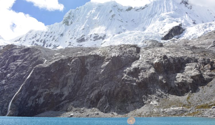
The Cordillera Blanca is part of the Huascarán National Park, established in 1975 and designated as a UNESCO World Heritage Site in 1985. The park spans over 340,000 hectares and is renowned for its rich biodiversity, glacial lakes, and over 30 peaks exceeding 6,000 metres.
Huascarán, the park’s namesake, is the highest peak in Peru and offers challenging climbs for mountaineers. The park is also home to Laguna 69, a breathtaking glacial lake at 4,609 metres (15,121 feet). The trek to Laguna 69 passes through fertile valleys with lush vegetation, including quenual forests (Polylepis species) and vibrant wildflowers. The trek itself, while not technically difficult, is physically demanding due to the high altitude, offering a challenging but rewarding experience for trekkers. The views of the surrounding snow-capped mountains, glaciers etc. from the lake are particularly breathtaking and make any discomfort and lack of breath on the way worthwhile.
Many of the views and vistas in the park are quite spectacular, of particular note on our way to Chavín was the area around Laguna Queracacha were a number of the indigenous came to take their llamas to drink the fresh water, all wearing traditional clothing. Nearby onto of a hill was a Christian figure complete with cross, thereby emphasising the deep control the Christian religion has over indigenous beliefs in Peru.


Huascarán National Park
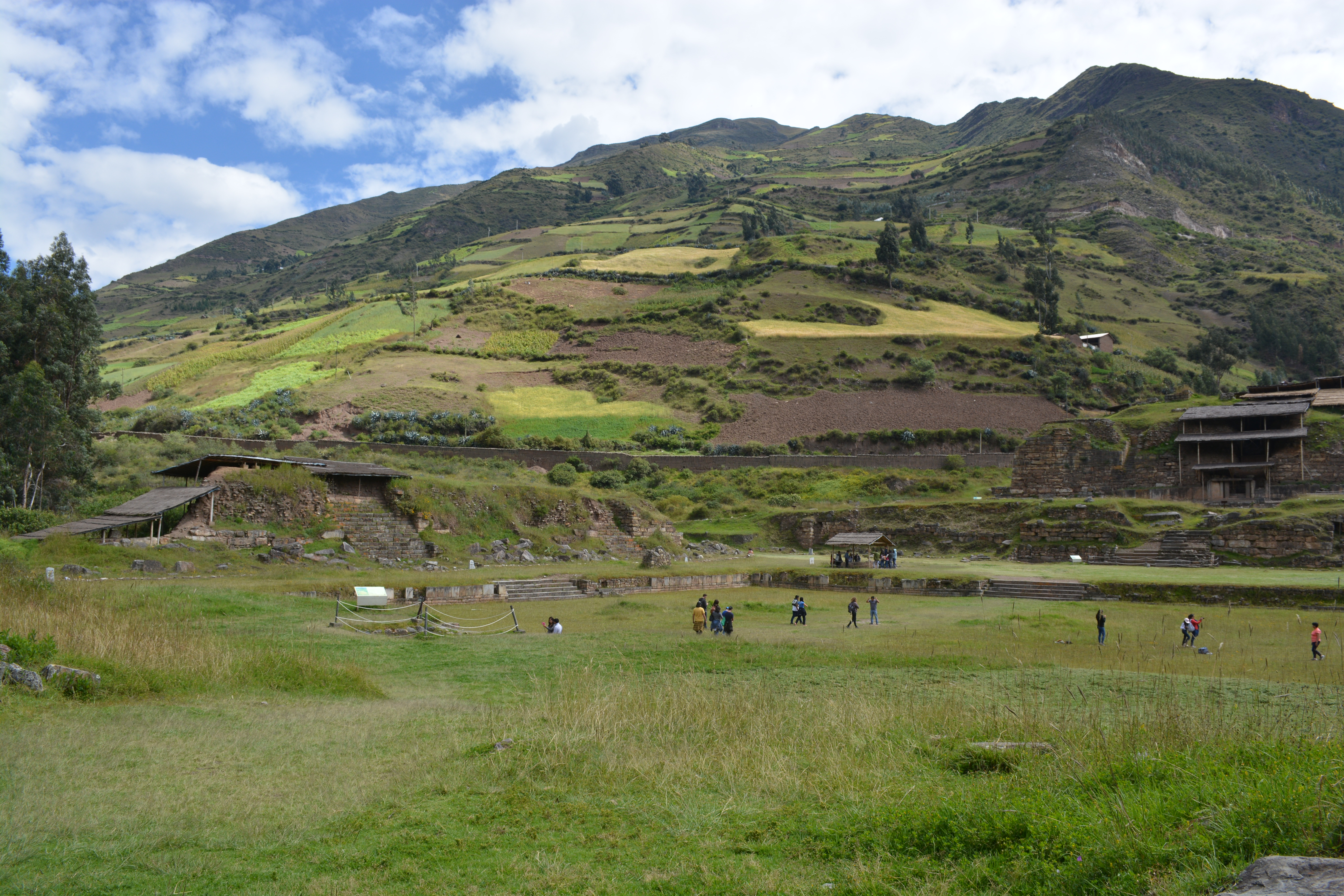
Agriculture in the park’s lower regions is vital for local communities. Traditional farming practices are used to cultivate crops such as potatoes, quinoa, maize, and oca (an Andean tuber). The terraces seen on the mountainsides are remnants of ancient agricultural techniques, allowing cultivation on steep slopes and helping prevent soil erosion. The fertile soils and microclimates within the park support a diversity of plant life, which in turn sustains local wildlife.
Chavín de Huántar
Located about 110 km southeast of Huaraz, Chavín de Huántar is an archaeological site that was once the religious and political centre of the Chavín culture. The site dates back to around 1200 BC and was in use until approximately 400 BC.
Key features of Chavín de Huántar include:
- The Old Temple (Templo Viejo): The oldest part of the complex, featuring a maze of underground passages and galleries.
- The New Temple (Templo Nuevo): An extension added around 500 BC, showcasing advanced architectural techniques.
- The Lanzón Monolith: A 4.5-meter-high carved stone located deep within the Old Temple, depicting a deity with human and feline features, possibly representing a god of agriculture or fertility.
- Tenon Heads: Stone carvings resembling gargoyles that once projected from the temple walls, representing transformational figures combining human and animal traits.


Chavín de Huántar
The Chavín people were skilled engineers and artisans, as evidenced by their intricate carvings and sophisticated drainage systems designed to prevent flooding during heavy rains. Their influence extended throughout the region, and they are considered a “mother culture” of the Andes, influencing subsequent civilizations such as the Recuay, Moche, and later the Incas.
After the decline of the Chavín culture around 400 BC, the area saw the rise of regional cultures. The Recuay culture(200 BC–600 AD) emerged in the same region, known for their distinctive pottery and stone carvings. Eventually, these cultures were absorbed into the expansive Inca Empire in the 15th century.

Environmental Challenges
The Cordillera Blanca is particularly vulnerable to the effects of climate change. Over recent decades, the glaciers that once blanketed the region’s towering peaks have been retreating at an alarming rate. Huascarán and other mountains have lost significant ice coverage, threatening local water supplies and increasing the risk of glacial lake outburst floods (GLOFs).
The melting glaciers impact agriculture, as the reduced water supply affects irrigation. Local communities are adapting by implementing water conservation techniques and diversifying crops to include more drought-resistant varieties. Efforts are also being made to monitor glacial lakes and implement early warning systems to protect against potential floods.
Final Thoughts
While Huaraz itself may not have the colonial charm of other Peruvian cities, its importance lies in its proximity to the Cordillera Blanca and the wealth of natural and cultural treasures that surround it. From the dramatic peaks of Huascarán to the ancient mysteries of Chavín de Huántar, Huaraz serves as the perfect base for exploring one of the most beautiful and culturally rich regions of Peru. The combination of stunning landscapes, rich history, and resilient communities makes this area a must-visit for any traveller seeking a deeper understanding of the Andean world.
Dates: 18/05/2018 to 21/05/2018 – Dragoman Days 2 to 4
