We left El Chaltén at sunrise, and the beguiling Mount Fitz Roy stood proudly, bathed in orange, in complete contrast to the various shades of blue from the previous days. It is a stunning mountain of many colours. The whole journey back North along Ruta40 to our next principal destination of San Carlos de Bariloche took the best part of three full days of driving and covered 1,430kms. On the way we bush camped in a salt valley near the Cueva de las Manos and then a more formal campsite in the town of Tecka before finally arriving at Bariloche.


Journey North from El Chalten
Ruta 40 (officially RN 40) is one of the longest roads in the world, stretching more than 5,000 kilometres from Cabo Vírgenes in the far south to La Quiaca on the Bolivian border. The route passes through some of Argentina’s most diverse landscapes, from the semi-arid steppe of Patagonia to the lush Lake District and the arid, high-altitude Puna in the north.
The Patagonian portion of Ruta 40, which runs through Santa Cruz and Chubut provinces, is characterised by vast plains, expansive skies, and the yellow and green tones of its steppe vegetation, including shrubs like coirón and hardy grasses. The climate here is harsh, with strong winds year-round, particularly in the south, and sparse rainfall. Temperatures vary dramatically between summer and winter, with cold nights even in the warmer months. As the journey progresses northward, the landscape becomes greener, especially as one approaches the Argentinian Lake District in Río Negro province, where the climate is wetter and more temperate, allowing for the growth of dense forests.
Ruta 40 is more than just a road; it symbolises the vastness of Argentina and its historical importance in connecting remote communities. Originally developed in the 1930s, the road has grown to become a route of pilgrimage for adventurers and those wishing to experience the diverse cultures, ecosystems, and histories of Argentina. Along the way, travellers encounter the heritage of Argentina’s indigenous peoples, including the Tehuelche in Patagonia, whose traditions can still be glimpsed in local crafts and customs. Further north, the road winds through regions influenced by Mapuche culture and eventually leads to areas rich in Inca history.


Bush Camp near Cave of Hands, Argentina
Table of Contents
Cueva de las Manos
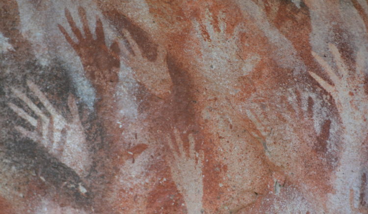
North of Santa Cruz Province, travellers reach the Cueva de las Manos, an ancient site dating back some 9,000 years. The cave walls and surrounding cliffs are adorned with silhouettes of hands and images of animals like the guanaco, which were hunted by the early inhabitants. The site, located in the Cañón de Río Pinturas, overlooks a gorge that once provided a strategic location for the indigenous population to hunt.
The paintings, a UNESCO World Heritage Site, are made with a mixture of red, yellow, white, and black pigments, created by blowing paint through a tube to form a negative silhouette of a hand. These images bear a striking similarity to other ancient cave paintings in Europe, particularly in France. The significance of the site lies not only in its antiquity but also in its role in connecting the people of Patagonia with the landscape they depended upon for survival. Today, the site is carefully preserved and managed, offering a glimpse into an ancient world but, before its listing it was vandalised by modern graffiti. Today and the paintings are well protected behind fences that align the walkway.


Cueva de las Manos Pintadas, Santa Cruz Province, Patagonia, Argentina
Population and the Role of Estancias
As we journeyed through Patagonia, the vast expanses of land were punctuated by estancias—massive ranches, some as large as small countries. These estancias, primarily dedicated to sheep farming, support sparse populations in one of the most remote regions on Earth. The human population here is largely concentrated in small towns and villages, with the estancias providing the backbone of the local economy. North of Santa Cruz, the semi-arid steppe gives way to greener pastures, supporting cattle rather than sheep, though the herds are much smaller than those in the Pampas. The population density remains low, but small towns like El Bolsón and Bariloche serve as cultural hubs, drawing artisans, craftspeople, and a growing number of tourists.

Salt Flat by Cueva de las Manos Pintadas, Santa Cruz Province, Patagonia, Argentina
Changing Landscapes: From Steppe to Lake District
The Patagonian landscape continued to reveal its vast skies and semi-arid vegetation, characterised by yellows and greens, interspersed with the brighter greens of poplar and eucalyptus trees that surround the estancias. Guanacos and rheas roam these plains, competing with the sparse herds of sheep for grazing land. However, as we progressed northwards, the landscape changed dramatically, signalling our arrival in the Argentinian Lake District. This region, with its lush green forests, snow-capped mountains, and crystal-clear lakes, is one of Argentina’s most stunning natural wonders. The transition from the arid steppe to this vibrant, verdant landscape was stark, as if we had entered a different world. El Bolsón, with its artisanal beers and craft markets, was our first stop in this region, offering a bohemian vibe in contrast to the more commercialised Bariloche further north.


El Bolsón, The Lake District, Argentina
Final Thoughts
The journey along Ruta 40 was a remarkable testament to Argentina’s vastness and diversity. From the golden plains of Patagonia to the green forests of the Lake District, the landscapes evolved continuously, each step revealing a unique element of Argentina’s natural and cultural heritage. Travelling this iconic route allowed us to experience both the extremes of the environment and the resilience of those who inhabit these remote areas. Ruta 40 offers an unforgettable blend of breathtaking scenery, ancient history, and a sense of freedom that only such an open road can inspire, leaving a lasting impression of Argentina’s wild beauty.
Dates: 27/03/2018 to 29/03/2018 Dragoman Days 23 to 26
